


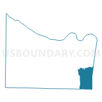
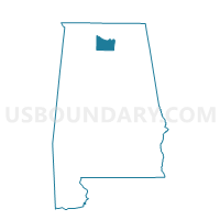
Ryan School, Morgan County, Alabama
About
Outline

Summary
| Unique Area Identifier | 522723 |
| Name | Ryan School |
| County | Morgan County |
| State | Alabama |
| Area (square miles) | 31.98 |
| Land Area (square miles) | 31.85 |
| Water Area (square miles) | 0.13 |
| % of Land Area | 99.58 |
| % of Water Area | 0.42 |
| Latitude of the Internal Point | 34.35779180 |
| Longtitude of the Internal Point | -86.61860340 |
Maps

Graphs
Select a template below for downloading or customizing gragh for Ryan School, Morgan County, Alabama


Neighbors
Neighoring Voting District (by Name) Neighboring Voting District on the Map
- Baileytown Town Hall, Cullman County, AL
- Brewer High School, Morgan County, AL
- Gum Pond Fire Station, Morgan County, AL
- Joppa Volunteer Fire Dept, Cullman County, AL
- Oden Ridge Volunteer Fire Dept, Morgan County, AL
- Oleander Meth Church, Marshall County, AL
- Ruth Fire Dept, Marshall County, AL
- Union Hill Jr High School, Morgan County, AL
Top 10 Neighboring County Subdivision (by Population) Neighboring County Subdivision on the Map
- Arab CCD, Marshall County, AL (15,490)
- Laceys Spring CCD, Morgan County, AL (9,034)
- Union Grove CCD, Marshall County, AL (6,430)
- Eva CCD, Morgan County, AL (5,655)
- Baileyton-Joppa CCD, Cullman County, AL (5,582)
Top 10 Neighboring Unified School District (by Population) Neighboring Unified School District on the Map
- Cullman County School District, AL (65,702)
- Morgan County School District, AL (50,012)
- Marshall County School District, AL (47,197)
Top 10 Neighboring State Legislative District Lower Chamber (by Population) Neighboring State Legislative District Lower Chamber on the Map
- State House District 27, AL (47,288)
- State House District 9, AL (45,371)
- State House District 11, AL (44,104)
Top 10 Neighboring State Legislative District Upper Chamber (by Population) Neighboring State Legislative District Upper Chamber on the Map
- State Senate District 3, AL (151,168)
- State Senate District 9, AL (144,554)
- State Senate District 4, AL (123,291)
Top 10 Neighboring 111th Congressional District (by Population) Neighboring 111th Congressional District on the Map
Top 10 Neighboring Census Tract (by Population) Neighboring Census Tract on the Map
- Census Tract 303, Marshall County, AL (6,430)
- Census Tract 56, Morgan County, AL (5,655)
- Census Tract 9641, Cullman County, AL (5,582)
- Census Tract 304.01, Marshall County, AL (4,583)
- Census Tract 304.02, Marshall County, AL (3,453)
- Census Tract 57.01, Morgan County, AL (2,658)
Top 10 Neighboring 5-Digit ZIP Code Tabulation Area (by Population) Neighboring 5-Digit ZIP Code Tabulation Area on the Map
- 35016, AL (16,778)
- 35670, AL (7,676)
- 35175, AL (5,041)
- 35621, AL (2,852)
- 35019, AL (2,117)
- 35087, AL (2,115)